Houston is the fastest-sinking city in the U.S. (SevenMaps/Shutterstock)
In a nutshell
- 34 million Americans live on sinking land across the 28 most populous U.S. cities, including unexpected inland areas like Denver and Indianapolis, not just coastal regions.
- Houston is sinking faster than any other city, with 42% of its land subsiding more than 5mm per year, largely due to groundwater overuse.
- Over 29,000 buildings are at high or very high risk of damage from land shifting beneath them, posing long-term threats to homes, infrastructure, and flood resilience nationwide.
NEW YORK — Your home could be sinking right now, and you probably have no idea. A new study reveals that major American cities are quietly subsiding beneath residents’ feet, with a shocking 34 million people living on sinking land. Houston residents face the most dramatic descent, but even New Yorkers, Chicagoans, and Denverites aren’t on solid ground anymore.
The study, published in Nature Cities, was conducted by researchers from several universities. Their research reveals that at least 20% of the urban area is sinking in all 28 of America’s most populous cities, with Texas cities showing particularly alarming rates. This slow-moving hazard damages buildings, roads, and critical infrastructure while exacerbating flood risks, and most Americans don’t even know it’s happening.
This problem extends well beyond coastal regions, affecting inland cities that many wouldn’t consider vulnerable to such threats. There is even concern in unexpected places like Denver, Indianapolis, and Detroit.
How Fast Are America’s Cities Sinking?
Using advanced satellite technology that measured surface changes with millimeter precision between 2015 and 2021, researchers discovered that nine major cities—including New York, Chicago, Houston, Dallas, Fort Worth, Columbus, Seattle, and Denver—are sinking at concerning rates exceeding 2 millimeters annually.
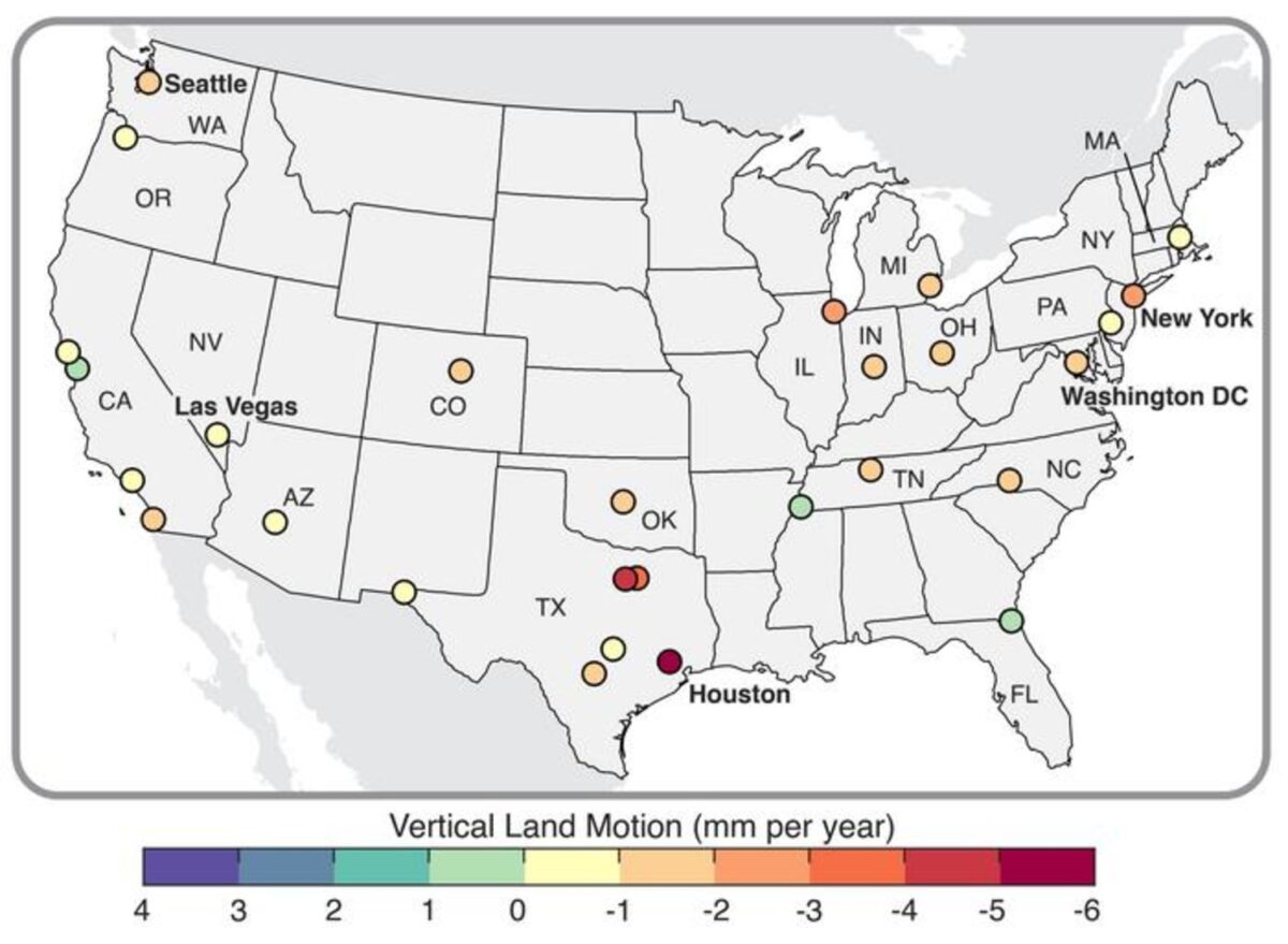
Texas cities face the most severe challenges, with Houston—America’s fastest-sinking metropolis—showing dramatic subsidence patterns (gradual sinking of the ground’s surface). A staggering 42% of Houston’s land area is sinking faster than 5 millimeters yearly, with 12% dropping at more than double that rate.
For perspective, even sinking by a seemingly small 3 millimeters yearly compounds over decades, potentially causing severe structural damage to buildings and infrastructure. The cumulative effect creates uneven foundation settling that cracks walls, misaligns doors and windows, and damages utility lines.
What’s driving this widespread sinking? The primary culprit appears to be excessive groundwater extraction. The research team found that 76% of land elevation changes across these cities correlate directly with groundwater depletion from confined aquifers.
When groundwater is extracted, pressure within the aquifer decreases, causing the land above to compact and sink. The sensitivity to this process varies significantly between cities based on their geological makeup.

Some cities demonstrate alarming vulnerability to minor groundwater changes. In New York and San Diego, researchers found a greater than 60% probability of significant sinking even at moderate groundwater depletion levels. This shows the soil in those areas is especially sensitive.
This explains why Texas cities show such dramatic sinking—the state’s rapid population growth and development have substantially increased water demands. But natural factors contribute, too, with glacial isostatic adjustment (land rebounding from ancient ice sheets) driving subsidence in northeastern cities like New York, Philadelphia, and Washington, D.C.
Buildings at Risk
The researchers estimate over 29,000 buildings across these cities face high or very high damage risk from subsidence-induced angular distortion, a measure of how structures tilt as land beneath them shifts unevenly.
Cities showing the highest proportion of at-risk buildings include San Antonio (1 in 45 buildings), Austin (1 in 71), Fort Worth (1 in 143), and Memphis (1 in 167). Collectively, San Antonio, Austin, and Houston account for over 82% of buildings classified at very high risk nationwide.

These are specific areas where infrastructure may already be compromised. While most structures remain at lower risk levels, the high-risk zones require immediate attention and intervention.
Eight major cities with severe subsidence—New York, Chicago, Los Angeles, Phoenix, Houston, Philadelphia, San Antonio, and Dallas—have experienced more than 90 significant flood events since 2000. Ongoing sinking amplifies these flood risks, particularly as climate change intensifies extreme weather events.
What’s The Solution?
“As opposed to just saying it’s a problem, we can respond, address, mitigate, adapt,” says Leonard Ohenhen from Columbia University, in a statement. “We have to move to solutions.”
For cities where groundwater extraction drives subsidence, managed aquifer recharge programs can help stabilize or even reverse sinking. Regulatory measures limiting extraction in vulnerable areas, alongside sustainable water management practices, have proven effective in places like Phoenix and Las Vegas, which previously experienced severe subsidence.
Cities with subsidence-induced infrastructure risks need retrofitting programs for vulnerable buildings, updated construction codes incorporating subsidence sensitivity, and enhanced monitoring of critical infrastructure.
The first critical step is awareness and acknowledgment of the problem. This new high-resolution mapping provides the foundation for targeted responses that can save billions in infrastructure damage while protecting millions of urban residents from gradual but potentially catastrophic consequences.
Without action, America’s sinking cities face a future of accelerating damage, increasing flood vulnerability, and mounting economic costs that will ultimately be borne by taxpayers and property owners. The problem beneath our feet demands attention before the ground literally shifts from under us.
List Of America’s Sinking Cities
According to the study, these 28 major U.S. metropolitan areas are experiencing varying degrees of land subsidence:
Cities with Highest Average Subsidence Rates (>2mm/year)
- Houston, TX
- Fort Worth, TX
- Dallas, TX
- New York, NY
- Chicago, IL
- Columbus, OH
- Seattle, WA
- Denver, CO
Additional Cities Affected by Subsidence (alphabetical)
- Austin, TX
- Boston, MA
- Charlotte, NC
- Detroit, MI
- El Paso, TX
- Indianapolis, IN
- Jacksonville, FL
- Las Vegas, NV
- Los Angeles, CA
- Memphis, TN
- Nashville, TN
- Oklahoma City, OK
- Philadelphia, PA
- Phoenix, AZ
- Portland, OR
- San Antonio, TX
- San Diego, CA
- San Francisco, CA
- San Jose, CA
- Washington, DC
KEY FINDING: The study estimates that at least 20% of urban land area is sinking in all 28 cities, with 25 of the 28 cities having at least 65% of their area affected by subsidence. This impacts approximately 34 million people across these metropolitan areas.
Paper Summary
Methodology
Researchers analyzed land subsidence across America’s 28 most populous cities using advanced satellite radar technology. They processed over 3,500 Sentinel-1 A/B satellite images acquired between 2015-2021 to create high-resolution maps (approximately 28 meters) of vertical land motion. They corrected for orbital errors and atmospheric effects, then validated measurements against ground-based GPS stations, finding 88% correlation. To understand groundwater’s role, they analyzed county-level groundwater withdrawal data and time series from 90 monitoring wells across 13 cities, using statistical techniques to correlate groundwater levels with surface elevation changes. They assessed infrastructure risk by calculating angular distortion (differential settlement between adjacent points) and combining this with building density data to create risk matrices for approximately 5.6 million buildings across these cities.
Results
The study found that at least 20% of the land area in all 28 cities is sinking, with 25 cities showing sinking in over 65% of their area. Nine cities exhibited average subsidence exceeding 2mm yearly, with Texas cities showing the highest rates (over 4mm yearly in Houston, Fort Worth, and Dallas). Houston had 42% of its land subsiding faster than 5mm yearly. Approximately 34 million people (10% of the US population) live on sinking land across these cities. The researchers found a strong correlation (87%) between groundwater level changes in confined aquifers and land subsidence rates. Over 29,000 buildings were classified at high or very high risk of damage, with San Antonio, Austin, and Houston containing 82% of buildings at very high risk nationally.
Limitations
The study acknowledges several limitations, including the lack of spatially resolved building damage data to validate risk assessments directly. The groundwater analysis was limited to 13 cities (46% of the study area) due to data availability constraints. The researchers note that while they established correlations between groundwater extraction and subsidence, local geological conditions create significant variability in response patterns. They also acknowledge that angular distortion risk thresholds vary based on construction materials, foundation types, and soil properties, which weren’t fully accounted for in the standardized risk assessment.
Funding and Disclosures
The research was supported by the Department of Defense, with partial funding from NASA (grant #80NSSC21K0061). The authors declared no competing interests that might influence the study’s findings or interpretations.
Publication Information
The paper titled “Land subsidence risk to infrastructure in US metropolises” was authored by Leonard O. Ohenhen (Columbia University, UC Irvine, Virginia Tech) and colleagues from multiple institutions including Virginia Tech, TNO Netherlands, UC Berkeley, Texas A&M, University of Colorado Boulder, Brown University, and FM Global. It was published in Nature Cities on May 8, 2025.